
A smartphone has more sensors and gadgetry than most people will ever use. Here’s a simple wee guide to how to get more out of your phone in the backcountry.
At the very least, learn how to use your phone to find your GPS coordinates in case of emergency (explained below).
A phone is useless in the backcountry without…
- extra battery life.
Smartphones eat electricity for breakfast. Bring spare charge. I have 5 batteries which cost $15 each. On a day trip using GPS I use one and take a spare. If you have a phone without replaceable batteries you can buy external batteries.
Be aware that Li-ion batteries are made with cobalt a product linked to horrible human rights abuses. Support any manufactures that make an attempt to source clean cobalt.
Check what is eating your battery life, put the phone on flight mode, close/uninstall unnecessary apps and turn off the GPS when you’re not using it. Extreme cold can drain your battery. Below about 5 degrees C keep your phone in a warm pocket.
- protection from damp and impact.
Get a good case or wrap you phone in a lot of plastic and padding. I have filmed under the sea with my lifeproof case so trust it will keep the phone dry.
- apps that work offline
Test what works offline by putting your phone in flight mode.
Maps and GPS
Lost in the murk, nothing beats having a satellite tell you where to go. I prefer a smartphone to a handheld GPS because its screen is much bigger and easier to navigate.
Tips
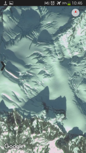
- Satellite imagery is extremely useful when route finding. If you are bush bashing, an aerial view can point you to fast terrain or around obstacles. When crossing glaciers, use satellite photos to see where crevasses are and how to avoid them.
- Open source maps like OpenStreetMap or OpenCycleMap have a huge coverage of trails worldwide. These are especially useful for finding tracks around towns or cities, I find them great for finding impromptu runs or day hikes while travelling.
- As with a handheld GPS, in potentially challenging terrain or weather conditions always make regular way points so that you can backtrack if needed. Record a track if you have enough battery.
For the weight saved on heavy paper maps, pack extra whiskey.
Map Apps
There are a million GPS apps out there. Here are some that I use. The most important features are the quality of the map, and being able to easily download maps for offline use.
GPS Status
Free app, speeds up getting a GPS lock. Definitely use it.
Viewranger
My favourite mapping app. Free app, but the best quality maps cost a bit.
Very usable, extremely easy to download maps for offline use. The maps available for free download are standard e.g. open source cycle maps. The quality of free downloadable and savable satellite imagery is average.
Tracking is great on this app, its super easy to export your track to gpx and email it to a friend.
I have bought some maps on this app, quality varies. NZ coverage is excellent with LINZ 1:50,000s. Canada is from toporama so have only 40m contours and lack tracks. The US USGS maps are fairly good. The viewranger website shows what maps are available and how much they cost.
OsmAnd
A must for anyone with a smartphone. Free, easy to use offline equivalent to google street maps. Really good for towns with icons for petrol stations and supermarkets etc. Extremely good for showing trails – better than bought maps.
OsmAnd recently released a contour extension for $3. Not the best good contours but they cover a huge area for little storage space.
Google maps
Good quality satellite imagery. not set up well for offline use.
How to save google satellite imagery for offline use:
- Create an ‘Offline area’ where you want to save imagery.
- Click settings then satellite. Now all the imagery that you load while online in the area should be saved for offline viewing.
- Zoom in and scroll around and around over all the terrain you want loaded.
This doesn’t work 100% well, I’ve found sometimes google decides do unload a few crucial pixels for me.
Satellite imagery and custom maps
The internet is full of fantastic free maps, map layers and imagery. A few good government made maps available for free download are linz (NZ), toporama (Canada) and USGS. Most mapping apps will charge you to access the same content. Edit and construct maps or layers using a GIS program like QGIS or Global Mapper. NB: Getting maps like this I often get caught in a tangle of file type incompatibilities.
To download high quality satellite imagery from providers like google use a program like SASPlanet. To look at very recent but low quality imagery Landsat (L8) is good – eg to look at snow coverage.
If you have found or made a georeferenced map you can use CompeGPS to convert it to a format viewable with the GPS app twonav on your phone. This is a reliable way to access offline satellite imagery.
Expedition Mountaineer Camilo Rada uses a smartphone on his first ascents

Even more important than navigation is a happy stomach. Some ideas and menus for lightweight but delicious backcountry cuisine are here.
Other tools
Inclinometer / bubble level
 I use this app to get a rough slope angle to help assess slope stability while skiing. Its a bit tricky, sometimes I lie the phone on my pole on the snow. Other times I look down the edge of the phone like a sight, both methods are accurate enough.
Camera
Photograph information you need for your trip so you don’t have to carry hard copies. Trip reports, guide books, climbing topos etc.
Take photos of the route from a distance so that once you’re in a labyrinth of crevasses or granite blocks you can find your way.
 Barometer
Excellent tool to follow your height gain/loss, but must be calibrated regularly as atmospheric pressure changes will weather as well as altitude.
Barometer+ is awesome, its easy to calibrate the altitude and constantly records using almost no battery, giving you a sweet height profile of your trip.
Roughly predict weather changes: If you are stopped for a while at the same altitude, pressure changes are due to changing weather. Rising pressure = good weather coming, lowering pressure = bad weather coming. As a rule of thumb don’t read into any changes less than 10hPa.
If there’s a proper frontal system it will occur when pressure is at a minima. It can rain while pressure is still dropping but the worst of it will be around the lowest pressure. After you should see pressure start to rise slowly once the system has passed.
Internet
Save for offline reading pages with weather or avalanche forecasts, trip reports, card game instructions.
Phone
Most smartphones have an inbuilt telephone that can be used converse or sing to people over large distances. Requires reception.
 Morale boosters
Pump some tunes for a boogie as you set up camp, listen to podcasts while stuck in your tent, record a spoken diary of your trip, spot constellations with Sky Map, or mountains with Peak scanner (if they get it working properly).
Compass
Just bring a real one that doesn’t consume electricity. But may as well have a compass app in case it gets eaten by some lost migratory birds.
Flashlight
This consumes a lot of battery so avoid using. I end up using it a lot.
Emergencies
Never rely on your phone for emergencies and always carry a emergency satellite beacon. However, your phone can be a massive help in sticky situations.
If you can connect to the cellphone network, call emergency services directly.
Use the GPS to find your location to give them. You do not need cellphone reception to use the GPS.
Haven’t done this before? Practice this at home in flight mode!
- Turn on GPS, open “Maps”

- Wait until you have a little blue dot of where you are
- Zoom in on the blue dot
- Long press on the blue dot until a red marker shows up on the blue dot
- In the search bar above are two numbers, the latitude and longitude coordinates
The blue dot is you, the coordinates are for the red marker. The larger transparent blue circle is the uncertainty which will get bigger as you zoom in.
Some apps claim to be able to find people in avalanches using bluetooth. These have been slammed as recklessly unsafe by the avalanche safety community.

Nice article!
Another cool feature of TwoNav is a very flexible power management. You can set it to turn the GPS on only every few minutes, so it records a rough track but saving a lot of battery. In “survival mode” the GPS is turned on every 5 minutes, and one battery can last a couple days easily if you don’y use the screen too much.
Also for the custom maps, In many cases it is worth the extra time. Because there are tematic paper maps with very good hiking, climbing, backcountry routes, and having those in a navigation App is pretty useful.
To the App kit, I would add one that gives you Moon/Sun rise/set times and Moon phases.
Thanks Arran!
LikeLiked by 1 person
Tried them all and highly recommend back country navigator, includes NZ topos and aerial
LikeLike
OruxMaps app is a very useful map app because it will read garmin format maps.
Garmin format maps are readily available online, eg http://www.frikart.no for topo maps of every country in Europe. They are also very compact.
Another tip to save battery when it is dark is to turn your auto-brightness off and turn the brightness way down.
LikeLike
Having too many spare Li ion batteries may cause a problem with safety regulations on air travel !
LikeLike